Keranjang Belanja Kamu Masih Kosong !
Google Translate


-195x250.jpg "TRIMBLE")


-195x250.jpg "NIKON")


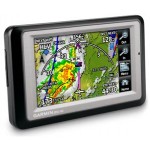
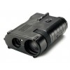
GPS Garmin Aera 795


Contact Us: (021) 53670757
Harga:
Rp0
Tidak termasuk pajak: Rp0
Harga:
Rp0
Tidak termasuk pajak: Rp0
Tidak termasuk pajak: Rp0
Gps GARMIN Aviation (Udara)
GPS GARMIN Aera 795 (Gps Udara)
- 3-D Navigation with MFD and EFB Capability
- 3D Vision perspective view
- 7" sunlight-readable touchscreen
- Fast 5 Hz GPS refresh rate
- Robust georeferenced charting options
- Document viewer and scratchpad

See in Virtual 3-D
 Revolutionary new 3D Vision technology shows a virtual 3-D behind-the-aircraft perspective of surrounding terrain derived from GPS and the onboard terrain database — a feature previously only available in our panel-mount avionics. Simply slide your finger across the touchscreen to rotate the view and show land and water features, obstacles, runways and airport signposts in relative proximity to the aircraft.
Using its forward-looking terrain avoidance capability, aera 795 predicts in advance where towers or obstacles may exist and shades the landscape with amber or red overlays to indicate those areas. 3D Vision and other flight data are presented smoothly and continuously thanks to the its internal GPS that provides position updates 5 times per second (5 Hz).
aera 795’s bright 7" diagonal high-definition sunlight-readable display makes this detailed mapping easy to see in any lighting conditions and works in both portrait and landscape mode. The physical design has been optimized to fit on the yoke or for use as a knee-mounted device. There are only 4 touch keys on the bezel for quick navigation to the most frequent used functions. All other functions are quickly accessed through intuitive onscreen icons with labels. This unique touchscreen interface even allows you to quickly pan across the map screen and pinch to zoom.
Go Paperless
 aera 795 fullfills the role of either a Class I or Class II electronic flight bag, greatly reducing the need to rely on paper charts in the cockpit. Initial georeferenced VFR sectional and IRF enroute charts come preloaded that show your aircraft’s position overlaid directly on the relevant chart. When in IFR map mode, the 795 can display victor airways, jet routes, minimum enroute altitudes and leg distance, much like what’s found on traditional enroute charts. Initial georeferenced Garmin FliteCharts provide approach charts and airport diagrams for the U.S., while pilots who prefer Jeppesen charts and diagrams can use optional Garmin ChartView service, which utilizes Jeppesen’s extensive library to provide global georeferenced charting capabilities.
aera 795 also includes a robust document viewer, so you can easily pull up weights and balances, flight manuals, raster charts or a variety of electronically formatted materials you download to the device. A “scratch pad” feature also allows you to quickly jot down clearances and other pertinent notes while en route, while a checklist viewer allows you to create customized and interactive electronic checklists.
 Enhance Situational Awareness
aera 795’s built-in terrain and obstacle database not only shows contours in 3D Vision mode, but also allows for a top-down view of your entire route. To help you navigate around unfamiliar airports, SafeTaxi® provides detailed taxiway diagrams and position information for many U.S., European or Canadian airports, while a private airport and heliport database greatly expands your emergency “nearest” options. FBO, ground transportation, lodging and other facility information for most U.S. airports are also available through preloaded AOPA Airport Directory Data; international pilots may choose to opt for global
AC-U-KWIK airport directory data instead.
Expand Your Portable
With 2 serial ports, aera 795 allows for simultaneous connectivity with other hardware. With an optional GTX 330 Mode S Transponder Interface, you can access Traffic Information Service (TIS) alerts, where available, right on the device while also sending frequencies to a SL30/40 radio or relaying position reports to other devices.
By adding optional City Navigator maps, both helicopter and fixed-wing pilots add street addresses as waypoints or direct-to destinations. The device includes an SD™ card slot for easy updates and expansions; update, manage and purchase the latest aviation data for your aera through flyGarmin.
![]()
![]()
![]()
Spesifikasi - Garmin Aera 795
Physical & Performance
- Unit dimensions, WxHxD 5.1"W x 8.0"H x 1.5"D (13.0 x 20.3 x 3.8 cm)
- Display size, WxH 3.6"W x 6.0"H (9.1 x 15.2 cm); 7.0" diag (17.78 cm)
- Display resolution, WxH 480 x 800 pixels
- Display type dual-oriented, bright, color WVGA TFT with adjustable backlighting and selectable screen orientation
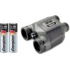
- Weight 26.4 ounces (748 g) with battery pack; 18.3 ounces (519 g) without battery pack; 12.7 ounces (361 g) RAM mount
- Battery rechargeable, replaceable Lithium-ion
- Battery life up to 3 hours with full backlight and GXM 40 connected (8 hours with 50% backlighting and XM connected)
- Waterproof No
- Voltage range 11-40
- SBAS/WAAS receiver high-sensitivity with WAAS position accuracy
- IFR or VFR VFR
Maps, Databases & Memory
- Basemap Yes
- Navigation database (includes Jeppesen® data) Yes
- Types of Jeppesen data full and ARTCC, FSS frequencies and final approach waypoints
- Navigation database coverage areas Americas
- Preloaded Terrain database Yes
- Preloaded Obstacle database Yes (U.S. and Europe only)
- Preloaded SafeTaxi™ airport diagrams Yes (U.S. only)
- Preloaded AOPA Airport Directory Yes (U.S. only)
- Preloaded Garmin FliteCharts® Yes (U.S. only)
- Preloaded low & high altitude enroute airways Yes
- Preloaded private airports Yes (U.S. only)
- Preloaded street maps No
- Ability to add maps Yes
- Accepts data cards yes (SD cards)
- Built-in memory internal solid state
- Waypoints/favorites/locations 3,000
- Routes 50
Features & Benefits
- Moving map Yes
- Patented panel page Yes
- HSI (GPS-based) Yes
- IFR map mode Yes
- Traffic Information Services (TIS) alerts compatible Yes
- Audible terrain alerts Yes
- Terrain resolution standard
- Smart Airspace Feature (generates and displays altitude-sensitive alerts) Yes
- Automatic logbook Yes
- Separate serial and USB interfaces Yes
- Voice prompts (e.g. "Turn right in 500 ft.") No
- Speaks street names (e.g. "Turn right ON ELM STREET in 500 ft.") No
- Lane assist (guides to proper lane for navigation) No
- 3-D map view No
- Bluetooth® wireless technology no
- Speed limit indicator (displays speed limit for most major roads in the U.S. and Europe) No
- Traffic compatible (routes around traffic with a receiver and subscription) No
- Custom POIs (ability to add additional points of interest) No
- XM WX Weather & Radio for U.S. & Canada compatible No
In The Box :
- aera 795
- Yoke mount
- DC cigarette adapter 12/24 volt cradle
- Home A/C cradle dock
- GA 25 remote antenna with suction cup mount
- USB cable
- Carrying case
- Touchscreen cleaning cloth
- Quick reference guide
- Complimentary single database update
- Pilot's Guide e-version (viewable on the document viewer)
Jual GPS Aviation Garmin Aera 795 dan lengkapi peralatan pekerjaan anda dengan Gps Udara atau Garmin Aviation Harga kompetitif Tentunya Gratis antar untuk Area Jakarta dan dapat dikirim keseluruh Indonesia, Jika membutuhkan Penawaran Harga hubungi sales kami Email info@teknologisurvey.com atau 0812-96566699
NOTE : GPS Aviation atau disebut juga gps aviasi digunakan oleh pilot atau pengguna pesawat dan helicopter untuk penerbangan
Nama Anda:
Tulis Pesan Anda: Note: HTML is not translated!
Rating: Buruk Baik
Masukkan kode dalam kotak di bawah ini:
Produk Terkait (1)
-
 Rp3thousand_point875thousand_point000 Rp3thousand_point875thousand_point000
 -
 Rp1thousand_point100thousand_point000 Rp1thousand_point100thousand_point000
 -
 Rp1thousand_point755thousand_point000 Rp1thousand_point755thousand_point000
 -
 Rp1thousand_point350thousand_point000 Rp1thousand_point350thousand_point000
-
 Rp10thousand_point650thousand_point000 Rp10thousand_point650thousand_point000
-
 Rp4thousand_point895thousand_point000 Rp4thousand_point895thousand_point000


-80x80.jpg "TRIMBLE")


-80x80.jpg "NIKON")


